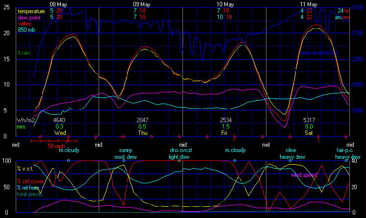
Local Forecast for Ballater
Issued by: BallaterSkies.co.uk
Updated: Monday, 5th January 2026, 04:00
 
Today

Snow
Snow
Tonight

Snow
Snow
Tuesday

Snow
Snow
Tuesday
night
Snow
Snow
Wednesday

Snow
Snow
Wednesday
night
Snow
Snow
Thursday

Snow
Snow
Thursday
night
Snow
Snow
2 mm.
1 cm.
<2 mm. 10 mm.
<8 cm.
5 mm.
<5 cm.
<2 mm. <2 mm.
<1 cm.
<2 mm. 2 mm.
1 cm.
High: 2° Low: -2° High: 1° Low: -1° High: 1° Low: -2° High: 1° Low: 0°
NW
6 mph
Light breeze
WNW
5 mph
Light breeze
WSW
3 mph
Light air
NW
9-17 mph
Moderate breeze
NW
7-15→4 mph
Moderate breeze
WSW
3 mph
Light air
SW
3 mph
Light air
NNW
3→9-19 mph
Fresh breeze


Today
 
Partly to mostly cloudy. A chance of snow in the morning, then a slight chance of snow in the afternoon. High 2°. Wind chill ranging from -5 to -2. Wind northwest around 6 mph. Chance of precipitation 40 percent. Precipitation (liquid equivalent) mostly around 2 mm. Snow accumulation about a cm.
Tonight
 
Mostly cloudy in the evening, becoming cloudy after midnight. A slight chance of snow after midnight. Low -2°, but temperatures rising after midnight. Wind west-northwest around 5 mph. Chance of precipitation 20 percent. Precipitation (liquid equivalent) mostly less than 2 mm. Little or no snow accumulation expected.
Tuesday
 
Mostly cloudy to cloudy in the morning, becoming dense overcast in the afternoon. Patchy light fog in the afternoon. A chance of snow in the morning, then snow likely in the afternoon. High 1°. Wind west-southwest around 3 mph. Chance of precipitation 80 percent. Precipitation (liquid equivalent) mostly around 10 mm. Snow accumulation 5 to 8 cm.
Tuesday night
 
Cloudy in the evening, becoming partly to mostly cloudy after midnight. Patchy light fog in the evening. Snow likely. Low -1°. Wind chill ranging from -5 to -2. Wind northwest around 9 mph, gusting to 17 mph. Chance of precipitation 60 percent. Precipitation (liquid equivalent) mostly around 5 mm. Snow accumulation 3 to 5 cm.
Wednesday
 
Mostly cloudy in the morning, becoming partly to mostly cloudy in the afternoon. A slight chance of snow. High 1°. Wind northwest around 7 mph, gusting to 15 mph, in the morning, becoming 4 mph in the afternoon. Chance of precipitation 20 percent. Precipitation (liquid equivalent) mostly less than 2 mm. No snow accumulation expected.
Wednesday night
 
Mostly cloudy to cloudy in the evening, becoming cloudy after midnight. A slight chance of snow in the evening, then a chance of snow after midnight. Low -2°, but temperatures rising after midnight. Wind west-southwest around 3 mph. Chance of precipitation 30 percent. Precipitation (liquid equivalent) mostly less than 2 mm. Snow accumulation less than one cm.
Thursday
 
Mostly cloudy in the morning, becoming cloudy in the afternoon. A slight chance of snow. High 1°. Wind southwest around 3 mph. Chance of precipitation 20 percent. Precipitation (liquid equivalent) mostly less than 2 mm. No snow accumulation expected.
Thursday night
 
Dense overcast. A slight chance of snow in the evening, then a chance of snow after midnight. Low 0°. Wind chill ranging from -5 to 0. Wind north-northwest around 3 mph in the evening, becoming 9 mph, gusting to 19 mph, after midnight. Chance of precipitation 50 percent. Precipitation (liquid equivalent) mostly around 2 mm. Snow accumulation about a cm.